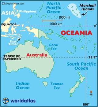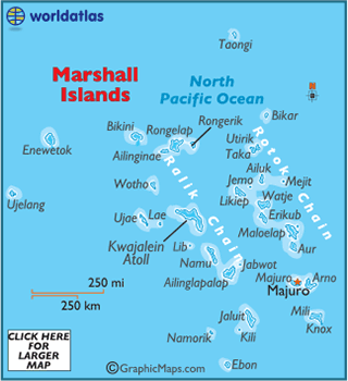


Marshallese Topography & Culture

Have you heard of the Ghyben-Herzberg law? Without this law there would be no Marshallese, nor other atoll dwellers. Here's how it works [from Wikipedia]:
In hydrology, a lens, also called freshwater lens or Ghyben-Herzberg lens, is a convex-shaped layer of fresh groundwater that floats above the denser saltwater, usually found on small coral or limestone islands and atolls. This aquifer of fresh water is recharged through precipitation. The fresh rainwater is "only" 40/41 as heavy as salt sea water and therefore floats on the heavier sea water. THIS RANDOM FACT OF NATURE HAS ALLOWED ALL ATOLL DWELLERS TO SURVIVE ON CORAL ATOLLS!


A cross-section of a coral atoll - as opposed to high volcanic
islands - built over millions of years upon extinct volcanoes
Culture of the Marshall Islands
The Marshallese "Wato"
To get a sense of a wato and an atoll in general, the following “tour” by once-resident Marshall Islands archaeologist Dirk Spennemann provides just that:
Let us take an imaginary walk through one such wato, and let us start at the ocean side. The vegetation on the oceanside commonly consisted of a mixed broadleaf forest, with a few tree species and a number of shrubs. These plants are very resistant to the salt-laden air the constant wind brings in from the breaker zone at the reef. The soil at the ocean shore is very gravelly with little humus content. The soil in this zone would consist of boulders and large cobbles, thrown up by the waves of the sea to a distinct strand wall, resembling the backbone of an island.
Going inland, the soil would gradually become finer, first gravel and then coarse-grained sand, and the humus content would increase. In this zone an abundance of breadfruit trees would have been planted, providing food. In fact the trees were planted in such an abundance that we can speak of a breadfruit forest.
In the very center of the island, there where the underlying ground water lens would be the thickest, taro patches, artificial depressions in the ground, would be present. These taro patches, in which swamp taro would be grown, were surrounded by Pandanus trees, preferable the low growing variety, not used for food but for mat-weaving.
These Pandanus would act as a windbreak for the large taro leaves, and would also act as screen to filter out any salt spray the winds may bring. We have to imagine that every piece of ground in the center would have been taken up by taro patches, Pandanus plants and roads/tracks. Going further towards the lagoon shore the vegetation zonation would once again show a wide zone of breadfruit forests, which would make way to utility and ornamental shrubs along the rear side of the household units.
The Matrilineage – “Bwij”
Land rights are inherited through the matrilineage [known as a “bwij”] or received as a gift, but are never purchased. The matrilineage is first and foremost a land-holding group, and the right to the use and produce of a given wato is vested in the matrilineal group and not in the individual.
The form of kinship practiced in the Marshall Islands [and Nauru to the south] is known as the “Hawaiian-Iroquois” matrilineal system. Special terms exist for mother’s brother [“wulleba”] and sister’s son [“jine”]. According to American anthropologist Leonard Mason, “the children of father’s brother and mother’s sister are regarded as siblings, and where the opposite sex is involved, this relationship carries the same restraint and sexual avoidance as for real siblings.” Also, a different term is used for cousins of the opposite sex when they are the children of father’s sister or mother’s brother. These so-called “cross-cousins” are the preferred marriage partners in the traditional Marshallese kinship system of preferential cross-cousin marriage.
Marshallese Land and Identity
To say that land and the Marshallese people are inextricably interwoven is to underestimate just how intimate and inter-connected these two are. The popular Marshallese cliché that “a Marshallese without land is no Marshallese at all” encapsulates this relationship. One draws one’s identity in Marshallese society from one’s land, and one’s sense of self and community derive directly from a particular wato [or watos] on a particular atoll. The Marshallese term “juknen” literally refers to living in a place forever. A popular Marshallese phrase, “Ijo ij pad im juknen ie,” means “Where I dwell and live forever and ever.”
Land not only represents the identity of each individual, but also the historical ties through successive generations of clan members [“jowi”] who have toiled before them. Aside from its inalienabilty and extreme scarcity, land for the people of Utrik represents their sense of continuity with their past. It is this unique sociocultural and historic tie to the past that provides the people with a sense of their place in the universe, and their sense of a secure future.

The Runit dome [L] topped by an 18-inch thick concrete cap contains radiation contaminated soil from previous nuclear tests. At a cost of $100 million and completed in 1979, the so-called "Tomb" has leaked around 99% of the radiation inside the Tomb into the Enewetak lagoon due to the porousness of coral atolls plus the twice-daily tidal action of the ocean.
The Bikini and Enewetak Contrasts
Although the people of Bikini and Enewetak fortunately avoided the fate of the Utrik and Rongelap people caught in the direct path of the Bravo fallout, these two Marshallese populations have nonetheless experienced irreparable sociological dislocation. In a society where land is the scarcest resource, and where the people’s identities as individuals and as members of society are intricately interwoven with their wato(s), the plight of the Bikini and Enewetak people has been severe.
In his 1954 dissertation, Leonard Mason recounted the historic decision to remove the indigenous Bikini people from their home atoll in 1946 to facilitate the upcoming series of nuclear tests [“Operation Crossroads”]. Citing the words of the Bikinians during this time, Mason quotes Iroij Juda: “If the United States government and the scientists of the world want to use our island and atoll for furthering development, which with God’s blessing will result in kindness and benefit to all mankind, my people will be pleased to go elsewhere.” Mason also quoted from former Secretary of the Interior Harold Ickes concerning the forced migration and re-location of the Bikini people to Rongerik Atoll, who said “The natives are actually and literally dying of starvation.”
The problem for the ex-Bikinians at Rongerik Atoll was the tyranny of the demographic law of “carrying capacity.” That is, where land is the scarcest resource in the Marshall Islands, there are very good reasons why some atolls have remained uninhabited, viz., that they are uninhabitable for a permanent population. Likewise, the further insult for the ex-Bikini people occurred at their final destination, Kili Island in the south. The problem with Kili – being a single and uninhabited island without a lagoon – is a formidable one for atoll dwellers used to using their fine sailing outriggers across pristine lagoons for fishing and recreational purposes. For atoll dwellers, the lagoon is considered to be their superhighway thoroughfare to the other islets for making copra and harvesting food. When I visited the ex-Bikini Marshallese on Kili Island in 1975, I vividly recall that they used the term “jiken kalbuuj” [lit. “the prison”] to refer to their “temporary” new locale.
Likewise, the people of Enewetak were forced to leave their home atoll to prepare for the upcoming nuclear tests [“Operation Sandstone”] by the Atomic Energy Commission and the Navy. According to the American anthropologist Laurence Carucci, in his interesting analysis of a “new” Enewetak tradition:
In December 1947 the residents of Enewetak, a strategically situated atoll approximately 3,000 miles southwest of Hawaii, were informed that that they would have to leave their homeland in order to allow the United States to use the atoll for nuclear testing. They did not want to depart, but they believed they had little choice . . .Caught between trust and fear, the residents left their villages on the tiny outer islets of Enewetak in sadness and boarded a military vessel in search of a `new and pleasant atoll’
The “new and pleasant atoll” – Ujelang – was in actuality a typhoon-ravaged and rat-infested atoll with about one-fourth the land area of Enewetak. Aside from the land discrepancy, the lagoon at Enewetak is almost four hundred square miles, as contrasted with the paltry twenty-five square mile lagoon at Ujelang Atoll. Again, the lesson of demographic carrying capacity was lost upon the U.S. government in their desire to initiate a second nuclear testing site in the Marshalls at the dawn of the Cold War.
As debilitating and sociologically disruptive as the Bikini and Enewetak re-locations have been for their respective communities, these Marshallese populations were spared the direct exposure of radioactive fallout and the subsequent surveys by the BNL medical team. In this sense then the Utrik [and Rongelap] experience has been substantively different – and more insidious - than that of their Bikini and Enewetak brethren.